LACounty.gov
| About LA County
🌐
A horizontal banner displays the official seal of the County of Los Angeles California on the left with circular text reading 'COUNTY OF LOS ANGELES CALIFORNIA' surrounding illustrated symbols, and to the right large teal text reads 'Kathryn BARGER' with smaller text below stating '5th District Supervisor • County of Los Angeles' separated by a small black circular icon, all set against a deep blue background.
LACounty.gov
| About LA County
🌐
  • HOME
    • SUPERVISOR KATHRYN BARGER
    • MEET THE TEAM
    • THE FIFTH DISTRICT
    • INTERNSHIP OPPORTUNITIES
    • COMMISSION OPPORTUNITIES
    • PUBLIC SAFETY AND JUSTICE
    • HOMELESSNESS AND MENTAL HEALTH
    • ECONOMIC DEVELOPMENT
    • FOSTER YOUTH
    • RESOURCES FOR VETERANS
    • PARKS AND RECREATION
    • BEACH BUS
    • PRESS RELEASES
    • VIDEOS
    • FIELD OFFICES
    • CONTACT FORM
    • NEWSLETTER SIGNUP
    • COMMENDATION REQUESTS
  • January 14, 2025

Barger Puts Spotlight on Damage Assessment Maps for Wildfire Survivors

Barger Puts Spotlight on Damage Assessment Maps for Wildfire Survivors

Barger Puts Spotlight on Damage Assessment Maps for Wildfire Survivors https://kathrynbarger.lacounty.gov/wp-content/uploads/2025/01/map.png 969 565 Supervisor Kathryn Barger Supervisor Kathryn Barger //kathrynbarger.lacounty.gov/wp-content/uploads/2025/12/white-logo-1.png January 14, 2025 May 21, 2025

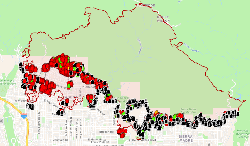
To help wildfire survivors who are wondering whether their house is still standing, Los Angeles County has launched an interactive map that shows the status of their property. The virtual map includes photos and a color-coded key that reflects levels of damage. 

“It’s been seven days since the Eaton Fire caused destruction, devastation, and displacement, and there are still countless residents who aren’t sure whether or not their homes are still standing,” Los Angeles County Board of Supervisors Chair Kathryn Barger said. “My constituents need to know the scope of what’s happened to their properties so they can begin applying for assistance and start their recovery process. This map is a trusted source of helpful information.” Residents displaced by the

Eaton Fire can visit recovery.lacounty.gov/eaton-fire to see the map. Each structure is labeled according to how severely it was impacted by the fire. Homes marked black suffered no damage, green are 1-9% affected, yellow are 10-25% affected, orange is 26-50% affected, and red is more than 50% destroyed. 

More properties will be added on a rolling basis as Cal Fire continues damage inspections. 

  • Wildfires
Read Previous
Barger Invites President-Elect Trump To Engage in Wildfire Recovery, Visit Los Angeles County
Read Next
Barger and Horvath Seek Evaluation of Emergency Notifications During Eaton and Palisades Wildfires
YOU MIGHT ALSO LIKE

ONE OF THE FOLLOWING

Barger on One-Year Anniversary of the Eaton Fire, Reaffirms Commitment to Survivors and Recovery
January 7, 2026
Barger Pays Tribute to Faith Leaders and Community Champions Who Turned Loss Into Leadership After Eaton Fire
September 23, 2025
Barger Applauds Grand Re-Opening of Grocery Outlet in Altadena
February 19, 2025
LA County Seal

CONTACT

500 W. Temple ST.

Room 869

Los Angeles, CA 90012

(213) 974-5555

Email Kathryn Barger

CONTACT

Get County and District 5 News

NEWSLETTER SIGNUP
  • ABOUT US
    • SUPERVISOR KATHRYN BARGER
    • MEET THE TEAM
    • THE FIFTH DISTRICT
    • INTERNSHIP OPPORTUNITIES
    • COMMISSION OPPORTUNITIES
  • PRIORITIES
    • PUBLIC SAFETY AND JUSTICE
    • HOMELESSNESS AND MENTAL HEALTH
    • ECONOMIC DEVELOPMENT
    • FOSTER YOUTH
  • RESOURCES & RECREATION
    • RESOURCES FOR VETERANS
    • PARKS AND RECREATION
    • BEACH BUS
  • MEDIA & NEWS
    • PRESS RELEASES
    • VIDEOS
  • CONTACT US
    • FIELD OFFICES
    • CONTACT FORM
    • NEWSLETTER SIGNUP
    • TEXT ALERT SIGNUP
    • COMMENDATION REQUESTS
  • twitter
  • facebook
  • instagram
  • flickr